Jeff Smallwood Photography
Adventures and Pain at Parkers Creek
share
Apr 15, 2012
Adventures at Parkers Creek
Sunrise over Parkers Creek
Click photo for larger view


So if a hiking trail by the Chesapeake Bay is named the "Bay Overlook Trail", is it too much to ask that it actually overlook the bay?

I've been interested in getting to Parkers Creek for sunrise photos over the bay for about a year. Parkers Creek is the largest undeveloped and relatively undisturbed watershed on the western shore of the Chesapeake.  For those that don't know, Washington DC and its suburbs are the western shore. The lands are managed by the American Chestnut Land Trust. The creek is a gorgeous, wandering shape and is surrounded by a huge marsh and forest full of wildlife. My destination is marked on the map below, where one of the trails ends at high ground right near the mouth of the creek.


View Parkers Creek and ACLT in a larger map


On the trail map and satellite view it appears as if you can see the bay and possibly the mouth of the creek from the trail end. I mean the trail is called "Bay Overlook", so I figured my assumption was safe.

The trail is about 1.7 miles and is a moderate to strenuous hike with lots of hills. With sunrise at 6:30am, I had to get a very early start, in the dark, in order to reach the overlook in time for first light.  A friend from the Calvert Photography Club, Daniel Coughlin, and I left the parking lot around 5am, flashlights in hand, and started our trek into the woods.

Right when the sun was hitting the horizon

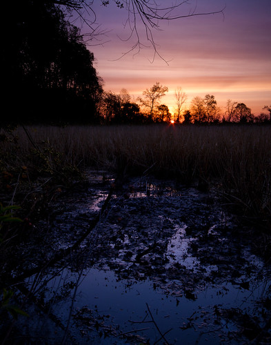
Timing was perfect, we arrived at the trail end just as the sky started to receive those first, deep blues of the morning. We had a good 50 minutes or more before the sun actually came up. Should have plenty of time to setup, make equipment decisions, and enjoy the brisk morning air.

I couldn't have been more wrong.

Arriving at the trail "overlook", I was surprised to find that the view from the platform is completely blocked by trees. Sure, through the trees and branches you can make out the bay in the distance. You have to look across the marsh, above the trees in the distance that border the beach, and there it is: a sliver of water. The view is very far from being a "Bay Overlook".

If you get up that early in the morning and hike that far in the dark, you don't want sunrise photos with trees blocking your view. You want a clear view of the scene. So what to do? Go off trail.

One of the many red-winged blackbirds in the marsh

Bringing up Google Maps, we pinpointed our location and decided we should try to move further down the hill to see if we could either get in front of the trees or at least find an opening from which to clearly see the marsh and sky. We took a good 20 minutes trying to find a new spot. The woods are still a mess from hurricane Irene, so we had to maneuver multiple downed trees, root balls, thicket, sticker bushes, and everything else you'd expect in an area like that w/o a trail. We finally found a deer trail on the steep edge of the hill that wandered around in front of the trees. The topography there is steep enough I had to be very careful with my footing...too far on the leaves and not enough in the dirt and you'd slip and risk sliding to the marsh edge.

Looks like a lovely place to take a bath, right?

With my camera bag on my back, flashlight in hand, on hands and knees, I crawled under two downed trees, under a holly bush and was presented with a decent scene, no trees blocking my view. The only problem? The patch of open view was completely overgrown with thorny vines. "Screw it" I said. I've come too far to stop now. I used my boots and camera bag to stamp down a little patch, giving me enough room to work. Setup the tripod and got out my gear.

 
Home sweet home for the morning -
my bag in a trampled spot of thorny vines
The view to my left, full of thorns.


For the next 50 minutes I stayed within a 5 meter radius. Wandered down to the marsh edge twice to try and capture reflections, then wandered back up to my original patch for a view from slightly higher ground.

My (finally) unobstructed view of the morning sky.
The moon is in the upper right.

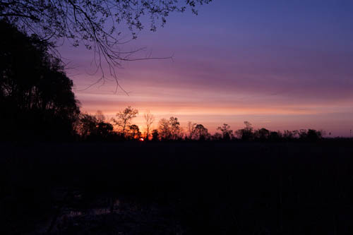
A constant battle between thorns, vines, a slippery slope, and a tripod with camera attached. Once the sun had been up for a while and the colors of morning were gone I crawled back the way I came and met up with Daniel (who stayed on the other side of the thicket at the marsh edge). My hands and sides were scratched up, and when I pulled my pants legs up to examine the damage, well, let's just say they don't look that good.

Thorns suck.

We explored the area a little more including the beach by the mouth of the creek before hiking back.

Daniel shooting on the beach after we left the "Overlook"


Painful? Yes. Worth it? Yes. Lesson learned? Yes.

Maybe next time I take a hiking trail, I'll assume its name is "Good Luck".

Comments
There are no comments on this post. Be the first one to comment using the form below.
Add Comment
(First name at least, last name is optional)
(Required, but will not be displayed)
(optional)

Get New Image

Comments disabled due to uncontrollable spam.